PEI
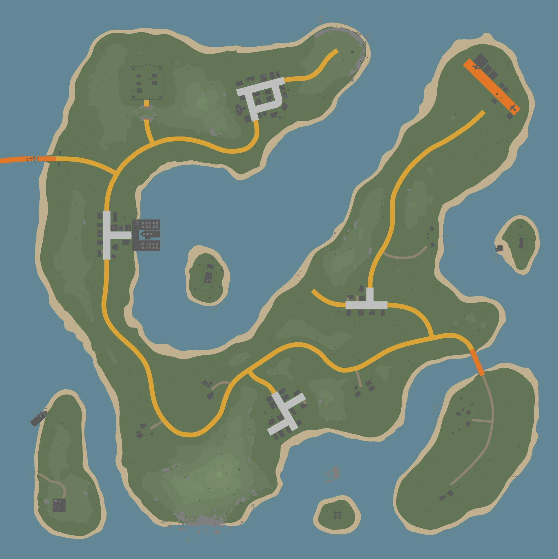
Map
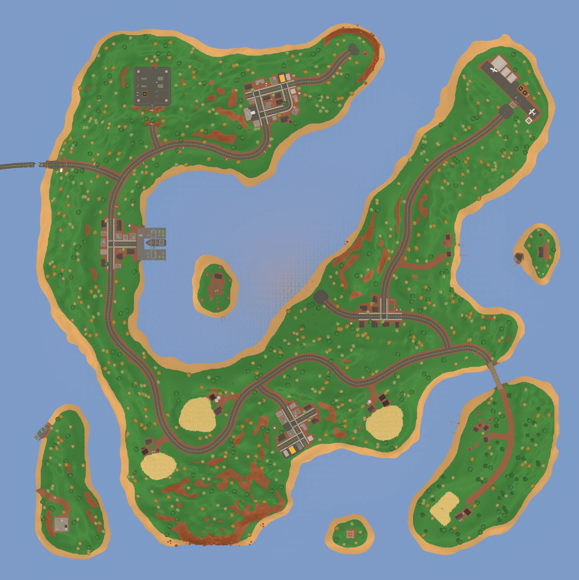
Satellite
- Survival
- 2,048 x 2,048 m
- 1,920 x 1,920 m
- 21
- 2,470
- 95
- 1,456
- 14
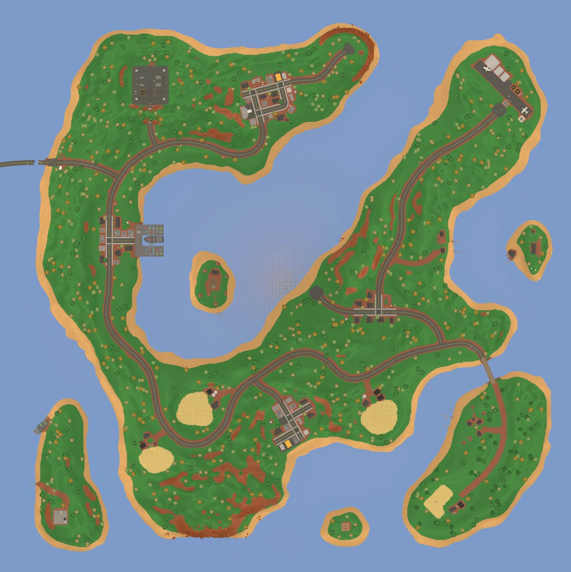
- Alberton
- Belfast Airport
- Cape Rock
- Charlottetown
- Confederation Bridge
- Courtin Isle
- Fernwood Farm
- Holman Isle
- Kensington Campground
- Liberation Bridge
- Montague
- O'Leary Prison
- Oulton's Isle
- Pirate Cove
- Souris Campground
- Stratford
- Summerside Military Base
- Taylor Beach
- Tignish Farm
- Wellington Farm
- Wiltshire Farm
Spots of each loot type, the places with the most of them, and the chance per spawned item.
Civilian Canada loot spots
354 spots
Most near Alberton (100), Stratford (77), Montague (71) Glue 11.9% Rope 11.9% Tape 11.9% Binoculars 11.4% Flashlight 11.1% Hammer 11.1%
Kitchen loot spots
239 spots
Most near Montague (57), Stratford (40), Alberton (36) Kitchen Knife 9.35% Bottled Water 5.67% Apple Juice 5.67% Grape Juice 5.67% Chips 5.67% Candy Bar 5.67%
Cloth loot spots
219 spots
Most near Alberton (65), Montague (31), Stratford (29) Fedora 6.33% Tophat 6.33% Orange Shirt 1.47% Purple Shirt 1.47% Green Shirt 1.47% Red Shirt 1.47%
Construction loot spots
209 spots
Most near Alberton (72), Belfast Airport (49), Wiltshire Farm (28) Cloth 13.6% Metal Scrap 13.6% Nails 13.6% Metal Sheet 3.63% Glue 3.63% Rope 3.42%
Camp loot spots
154 spots
Most near Kensington Campground (60), Souris Campground (49), Stratford (15) 20 Gauge Shells 10.2% Fishing Hat 5.35% Fishing Top 5.22% Fishing Bottom 4.97% Camp Axe 3.08% Pocketknife 3.08%
Farm loot spots
151 spots
Most near Wellington Farm (55), Fernwood Farm (40), Wiltshire Farm (38) Farmer Top 12.3% Farmer Bottom 12.3% Straw Hat 12.3% 20 Gauge Shells 5.72% Low Caliber Civilian Ammunition Box 4.20% Arrow 3.08%
Military Canada loot spots
141 spots
Most near Summerside Military Base (117), Confederation Bridge (24) Military Knife 16.0% Forest Military Top 11.1% Forest Military Bottom 11.1% Forest Military Vest 8.94% Forest Military Helmet 4.59% Forest Beret 4.59%
Food loot spots
114 spots
Most near Stratford (61), Charlottetown (45), Alberton (8) Apple Juice 6.04% Grape Juice 6.04% Canned Cola 6.04% Canned Soda 6.04% Chips 4.83% Candy Bar 4.83%
Gas loot spots
84 spots
Most near Charlottetown (43), Stratford (17), Montague (10) Flashlight 18.3% Portable Gas Can 6.04% Blowtorch 6.04% Carjack 6.04% Socketwrench 6.04% Blue Flare 5.53%
Medic loot spots
79 spots
Most near Charlottetown (26), Stratford (23), Alberton (18) Bandage 11.9% Cough Syrup 11.9% Purification Tablets 11.9% Vitamins 11.9% Cloth 11.9% Antibiotics 5.50%
Militia loot spots
79 spots
Most near Holman Isle (31), O'Leary Prison (16), Alberton (11) Butterfly Knife 11.3% Machete 11.3% Katana 11.3% Low Caliber Ranger Ammunition Box 6.98% 7x Scope 4.70% Kobra Sight 4.70%
Chef loot spots
75 spots
Most near Alberton (31), Stratford (27), Charlottetown (17) Butcher Knife 6.69% Frying Pan 6.69% Bottled Water 5.02% Chips 5.02% Apple Juice 5.02% Grape Juice 5.02%
Police loot spots
71 spots
Most near Belfast Airport (25), Stratford (21), Charlottetown (18) Cobra Magazine 15.9% Low Caliber Civilian Ammunition Box 15.1% Police Bottom 10.9% Police Cap 10.9% Police Top 10.9% Cobra 10.2%
Prison loot spots
69 spots
Most near O'Leary Prison (58), Stratford (6), Charlottetown (5) Prisoner Top 42.9% Prisoner Bottom 41.8% Butterfly Knife 5.49% Handcuffs 4.95% Handcuffs Key 4.95%
School loot spots
68 spots
Most near Stratford (32), Montague (26), Courtin Isle (6) Hockey Stick 22.9% Candy Bar 16.7% Chocolate Bar 16.7% Grape Juice 16.7% Apple Juice 16.7% Red Daypack 1.30%
Airport Canada loot spots
61 spots
Most near Belfast Airport (61) Glue 11.4% Rope 11.4% Tape 11.4% Binoculars 10.9% Flashlight 10.6% Hammer 10.6%
RCMP loot spots
59 spots
Most near O'Leary Prison (59) Binoculars 24.6% 12 Gauge Shells 20.9% RCMP Top 8.08% RCMP Bottom 8.08% RCMP Hat 8.08% Bluntforce 7.41%
Fire loot spots
55 spots
Most near Stratford (26), Charlottetown (24), Confederation Bridge (5) Fire Axe 23.5% Firefighter Top 10.2% Firefighter Bottom 10.2% Firefighter Helmet 10.2% Blue Flare 7.65% Green Flare 7.65%
Post loot spots
38 spots
Most near Alberton (20), Charlottetown (18) Glue 33.3% Rope 33.3% Tape 33.3%
Beach loot spots
27 spots
Most near Taylor Beach (14), Courtin Isle (13) Apple Juice 31.9% Grape Juice 31.9% Canned Cola 6.94% Canned Soda 6.94% Bottled Soda 6.94% Bottled Cola 6.94%
Library loot spots
26 spots
Most near Stratford (26) Cloth 8.25% Tape 8.25% Rope 8.25% Glue 8.25% Binoculars 3.75% Flashlight 3.75%
Botanist loot spots
21 spots
Most near Stratford (21) Fertilizer 17.1% Carrot Seed 9.69% Corn Seed 9.69% Lettuce Seed 9.69% Potato Seed 9.69% Rice Seed 9.69%
Guns Canada loot spots
21 spots
Most near Stratford (21) 1911 Magazine 21.7% Ace Clip 21.7% Sportshot Magazine 21.7% Low Caliber Civilian Ammunition Box 15.0% 1911 5.70% Ace 5.70%
Booty loot spots
17 spots
Most near Pirate Cove (17) Loonie 50.0% Toonie 50.0%
Special Canada loot spots
13 spots
Most near Summerside Military Base (7), Confederation Bridge (6) Fragmentation Grenade 20.8% Tactical Laser 5.01% Tactical Light 5.01% High Caliber Military Ammunition Crate 4.35% Military Barrel 3.34% Military Muzzle 3.34%
Lighthouse loot spots
11 spots
Most near Cape Rock (11) Glue 6.40% Tape 6.40% Rope 6.40% Cloth 6.40% Metal Can 6.40% Rain Pants 5.00%
Pizza loot spots
8 spots
Most near Alberton (8) Dough 33.3% Cheese 33.3% Tomato 33.3%
Doughnut loot spots
7 spots
Most near Stratford (7) Dough 90.0% Maple Syrup 10.0%
Civilian zombies
562 spots
Health 100 · Damage 15 · 3 XP Most near Stratford (125), Charlottetown (113), Alberton (111)
Military zombies
149 spots
Health 100 · Damage 15 · 5 XP Most near Summerside Military Base (115), Confederation Bridge (34)
Farm zombies
134 spots
Health 100 · Damage 15 · 3 XP Most near Wellington Farm (43), Fernwood Farm (33), Wiltshire Farm (29)
Construction zombies
131 spots
Health 100 · Damage 15 · 3 XP Most near Alberton (49), Belfast Airport (31), Stratford (24)
Camp zombies
86 spots
Health 100 · Damage 15 · 3 XP Most near Kensington Campground (42), Souris Campground (35), Liberation Bridge (5)
Chef zombies
55 spots
Health 100 · Damage 15 · 3 XP Most near Alberton (19), Stratford (19), Charlottetown (17)
RCMP zombies
50 spots
Health 100 · Damage 15 · 3 XP Most near O'Leary Prison (50)
Prison zombies
49 spots
Health 100 · Damage 15 · 3 XP Most near O'Leary Prison (41), Charlottetown (4), Stratford (4)
Police zombies
44 spots
Health 100 · Damage 15 · 3 XP Most near Belfast Airport (22), Stratford (12), Charlottetown (10)
Medic zombies
41 spots
Health 100 · Damage 15 · 3 XP Most near Stratford (17), Alberton (12), Charlottetown (12)
Militia zombies
39 spots
Health 100 · Damage 15 · 3 XP Most near Holman Isle (37), Cape Rock (2)
Fire zombies
33 spots
Health 100 · Damage 15 · 3 XP Most near Charlottetown (14), Stratford (12), Belfast Airport (7)
Gas zombies
26 spots
Health 100 · Damage 15 · 3 XP Most near Charlottetown (16), Stratford (10)
Food zombies
23 spots
Health 100 · Damage 15 · 3 XP Most near Charlottetown (13), Stratford (10)
Fishers zombies
16 spots
Health 100 · Damage 15 · 3 XP Most near Kensington Campground (8), Souris Campground (6), Liberation Bridge (2)
Pilot zombies
12 spots
Health 100 · Damage 15 · 3 XP Most near Belfast Airport (12)
Lighthouse zombies
4 spots
Health 100 · Damage 15 · 3 XP Most near Cape Rock (4)
Special mega zombie
2 spots
Health 2,999 · Damage 33 · 40 XP Most near Confederation Bridge (1), Summerside Military Base (1)
Bicycle12.2% of vehicle spawns
Offroader8.27% of vehicle spawns
Hatchback7.78% of vehicle spawns
Truck7.54% of vehicle spawns
Van7.30% of vehicle spawns
Sedan6.81% of vehicle spawns
Quad6.67% of vehicle spawns
Firetruck6.32% of vehicle spawns
Police Car4.91% of vehicle spawns
Dirtbike3.51% of vehicle spawns
Tractor3.51% of vehicle spawns
Runabout3.16% of vehicle spawns
Police Motorcycle2.46% of vehicle spawns
Roadster2.43% of vehicle spawns
Rally Car2.43% of vehicle spawns
Military Offroader2.38% of vehicle spawns
Ambulance2.11% of vehicle spawns
Jetski2.11% of vehicle spawns
Police Launch2.11% of vehicle spawns
Armored Offroader1.44% of vehicle spawns
Otter1.05% of vehicle spawns
Tank1.05% of vehicle spawns
Transport Heli0.939% of vehicle spawns
Ural0.815% of vehicle spawns
APC0.627% of vehicle spawns
Hummingbird0.113% of vehicle spawns